Welcome!
McCarthy Road Planning and Environmental Linkages (PEL) Study
The Federal Highway Administration - Western Federal Lands (WFL) Highway Division, in partnership with the Alaska Department of Transportation and Public Facilities (DOT&PF) and the National Park Service (NPS), are working together to conduct a corridor study along the McCarthy Road.
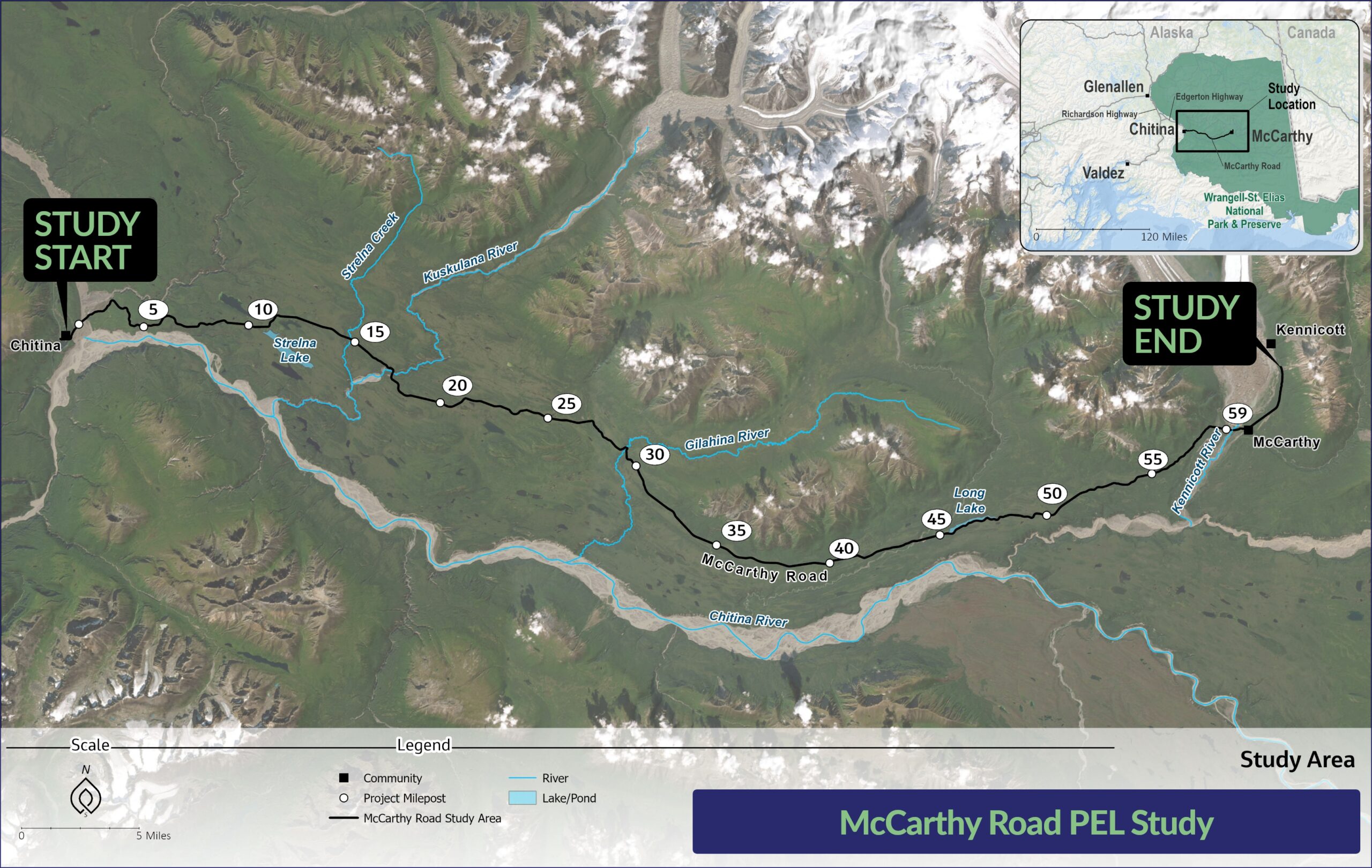
Thank you for taking the time to visit the McCarthy Road Planning and Environmental Linkages (PEL) Study website. This study will identify transportation-related improvements for the McCarthy Road corridor. This could include improvements related to road condition and drainage issues, hazards such as landslides, and bridges and culverts. Enhancements related to visitor and recreation access will also be considered. The study corridor extends 60 miles from the eastern end of Chitina to the Kennicott River, and another four miles to the southern end of the Kennicott subdivision.
Project No. AK FLAP DOT 198(4)
About
Over the years, residents and visitors have provided feedback that calls for the need to improve the reliability of access and public safety along the McCarthy Road Corridor. In response, the Federal Highway Administration - Western Federal Lands (WFL) Highway Division partnered with the Alaska Department of Transportation and Public Facilities (DOT&PF) and the National Park Service (NPS) to prepare the McCarthy Road PEL study. The study is funded through the Federal Lands Access Program.
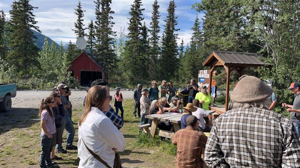
McCarthy study team and community meet-and-greet in June 2023
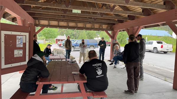
Chitina study team and community meet-and-greet in June 2023
The PEL framework encourages decision-makers to incorporate environmental considerations, community, and economic goals early in the transportation planning process. Through a PEL process, this study will:
- Explore existing opportunities along the McCarthy Road
- Identify and evaluate potential transportation and access improvements; and
- Propose recommendations for future improvement projects.
The McCarthy Road PEL study will have two outcomes:
A framework that identifies prioritized transportation-related projects along the McCarthy Road, and a plan to complete those projects.
Bring together stakeholders and users of the McCarthy Road to improve communication and build relationships to identify transportation and access needs.
Public and stakeholder involvement will be integrated throughout the PEL process. Stakeholders, such as the DOT&PF, Wrangell St. Elias National Park and Preserve, Ahtna, local businesses, and the public will come together to identify current and future needs within the study area. WFL will consult directly with Native Village of Chitina.
The Road
McCarthy Road Fast Facts

Main Access
The McCarthy Road is the main overland access into Wrangell-St. Elias National Park and Preserve.

Population
Approximately 100 people live in the Chitina area, 100 people live in the McCarthy area year-round, and at least a dozen families within the road corridor in-between.

Daily Vehicles
Historic annual average daily traffic on the McCarthy Road (at Chitina) is 205 vehicles.

Peak Vehicles
During the peak season, average daily traffic jumps to 400 vehicles.

Road Maintenance
The road is owned by DOT&PF and maintained seasonally from May 15 to October 1.
Schedule
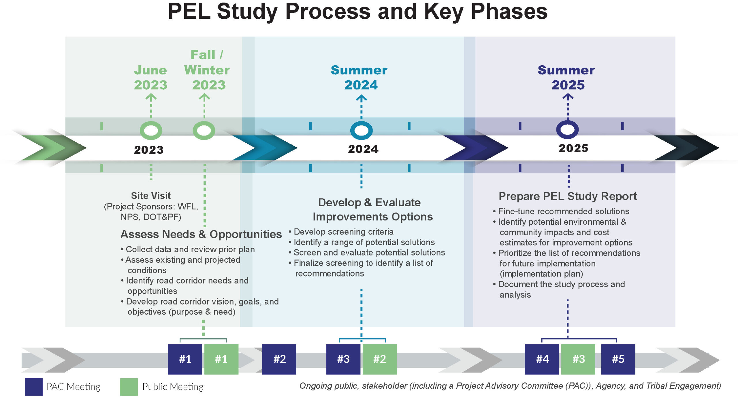
The PEL Study started in Summer 2023 and will be completed in Summer 2025. The PEL process and study will be done in partnership with Native organizations, the public, stakeholders, and federal and state resource agencies.
Get Involved
Be a part of the study! Public meetings will be held during each phase of the study:
- 1. Assessing needs and opportunities (Meeting #1 – Late 2023) – Completed
- 2. Developing and evaluating potential improvement options (Meeting #2 – Summer 2024) – Completed
- 3. Preparing the PEL Study and draft recommendations (Meeting #3 – Spring 2025)
Stay up-to-date with project news and ways to engage.
Click here to join our mailing list or leave a comment or question. If you need more space for your comment, please email Kim.Wetzel@Jacobs.com.
Project Advisory Committee (PAC) Formation
The McCarthy Road PAC will meet throughout the study to provide guidance and input. The PAC consists of representatives from DOT&PF, NPS, Native Village of Chitina, Ahtna, local residents, and organizations representing tourism, economic development, and regional planning organizations.
Previous Engagement
The goal of the first round of public engagement was to identify needs and opportunities along the McCarthy Road corridor. The first of the project’s three public meetings was held as an online open house, available from November 29, 2023, to January 10, 2024. Prior to the online open house, the team hosted the first PAC meeting on November 16, 2023, and launched a project website. We also held an informal study team meet-and-greet with the public in Chitina and McCarthy in June 2023.
The first online open house allowed for public comments to be gathered in multiple ways, including an interactive mapping tool that allowed visitors to tag their comments to specific locations along the study corridor. The online open house also contained a link to a poll intended to solicit more detailed input on corridor vision, purpose statement, and goals.
More than 300 comments were collected throughout the first engagement period. Popular comment themes included:
- Access (e.g., road reliability, parking, bridge access)
- Road design and road character
- Bridge condition (e.g., Gilahina, Kennicott River)
- Road condition/maintenance (e.g., drainage, culverts, chip seal, glaciation, brush clearing, sight distance, potholes, erosion, winter maintenance)
- Hazards (e.g., landslide, avalanche, bluffs)
- Safety (e.g., speeding, emergency services)
- Community considerations and economic development
- PEL process
- Visitor experience (e.g., pullouts, waysides, signage)
- Recreation opportunities (e.g., trails, lake access, boat ramp)
- Multi-modal accommodation (i.e., bicyclists, pedestrians)
A detailed report on the first round of engagement can be viewed here.
Documents
PEL Study Documentation
- Public Meeting #2 Summary: Coming Soon
- Solutions Development & Evaluation: Screening Process Overview (July 2024) [1.3MB]
- Needs & Opportunities Assessment Report (March 2024) [File size 25MB]
- Needs and Opportunities Assessment Report Appendices (March 2024) [File size 46MB]
- Public Meeting #1 Summary (January 2024)
- Newsletter 1 (November 2023)
Contact Us
Federal Highway Administration – Western Federal Lands, Highway Division
Seth English-Young, Planning Team Lead
seth.english-young@dot.gov
(360) 619-7803
Alaska Department of Transportation and Public Facilities
Paul Eckman, DOT&PF Northern Region Design Engineer
paul.eckman@alaska.gov
(907) 451-2275
National Park Service
Joshua Scott, Wrangell-St. Elias National Park and Preserve Chief of Lands & Planning
joshua_scott@nps.gov
(907) 822-7243
Jacobs
Leslie Robbins, Project Manager
leslie.robbins@jacobs.com
Kim Wetzel, Public Involvement Lead
kim.wetzel@jacobs.com
(90seven) 440-1591